Go to Grand Canyon, Sedona, Phoenix Area, Other Places in AZ, or Cactus Photos
Arizona
Since I used to live in Arizona, I thought it fitting to show what it looks like in the American Southwest. People automatically think of Arizona as a dry and hot, drab, grey-brown place with thorns. No kidding - it is. BUT ... Arizona also boasts some of the most diverse scenery, fauna, and flora imaginable from the well-known hot dry desert with cacti, rattlesnakes, and scorpions, to expansive alpine forests and mountains over 12,000 feet in elevation. Arizona is home to much more than rattlers, too, including white-tail and mule deer, pronghorn, elk, javalina (collared peccary), and more surprisingly creatures like bobcats, mountain lions, and hummingbirds. Visit my gallery for a few pictures from to the Desert Botanical Gardens in Phoenix
Update: We just went back for a visit - new pics from 2011 here.
All of the pics on this page are thumbnail sized links to larger versions.
The Grand Canyon, what many call a Natural Wonder of the World, is one of the most spectacular examples of erosion anywhere. It is unmatched in the magnificent vistas it offers to visitors on the rim, the depth of the canyon, and the brutal fact that any hike must first go down, then back up...
Easily accesible by car (subject to seasonal closures), the Grand Canyon is about 1.5 hours north-west of Flagstaff, and can be done as a day-trip from Flagstaff. At over 4 hours from Phoenix, there isn't much point in trying to see it from the Phoenix area in one day.
I was there again in Spring of 2004, here are some additional pictures.
Back to Top.
| Sedona and Red Rock Country |
|
|
 |
 |
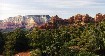
| Red Rock Formations looking towards Wilson Mtn from Marg's Draw trail. |
More Red Rocks - around Scheurman Mtn at the Red Rock Loop Road. |
|
|
 |
 |
| Snoopy Rock - It really does look like Snoopy on his back with his nose in the air. |
Colored skies during sunset from the Sedona Airport |
Sedona is located about 2 hours north of Phoenix, and about 1/2 an hour south and west of Flagstaff, just off of I-17 that runs from Phoenix to Flagstaff.
Extensive sandstone and limestone redrock formations have been carved into the landscape of Sedona, creating a scene reminiscent of the Grand Canyon on a much smaller scale. Sedona is also home to various arts and crafts fairs and shops, a busy tourist season with hiking, mountain biking, and jeep roads (and tours), and people say there are several "vortexes" in and around Sedona.
Back to Top.
| In the Phoenix Vicinity |
|
|
In June, 2005, we went on a Hot Air Balloon ride, over the northern outskirts of Phoenix.

|
 |
 |
| Apache Lake |
Canyon Lake |
East of the city, on the way to Roosevelt Lake lie both Apache and Canyon lakes. Nestled in canyons of the Tonto National Forest the lakes offer extensive water sports activities including boating and fishing as well as cruise boat rides on Canyon Lake.
 |
 |
| Four Peaks |
Bartlett Lake Reservoir |
|
|
 |
 |
| Rio Verde |
Snow! In Scottsdale! |
Four Peaks is located about 1 hour east of Phoenix, or more depending on the condition of the road to the pass, by taking the B-Line Highway out of Fountain Hills to the Four Peaks Road turn-off after which the pavement ends. At over 7600 feet elevation Four Peaks often gets winter snow and is visible from the city. The picture above was taken in December, from the north at the first of the four main peaks
Bartlett Lake is a dammed reservoir to the northeast of the city, about an hour's drive. The road to Bartlett Lake runs out of Carefree. While most of the lakeshore is accessible by car or 4x4, there are still a few places where you can find some privacy - even when it gets very busy in the summertime with boats, jet-skiers, and everyone else in the Phoenix area looking for water. The picture above is from the very northern tip of the lake.
The Rio Verde drains out of Bartlett Lake and these rock formations are within a few miles of the lake. While the river is at times shallow enough to drive through, it is one of the few full-time rivers in the area and is not canal-fed. The area where this picture was taken can be reached by taking Dynamite Road (also known as Rio Verde) east from North Scottsdale, until it ends, and heading north along the river.
As for snow in Scottsdale - in 4 winters I've been here, it has happened two or three times. Of course it never lasts more than a few hours, but it's always amazing and strange to see snow and saguaro or cholla cacti side by side
Back to Top.
| Other Places in Arizona |
|
|
 |
 |
 |
| The actual (2nd) London Bridge, Lake Havasu City |
Along the Senator Highway |
Sunrise Ski Resort |
In 1962, the London Bridge was falling down. Built in 1831, the bridge couldn't handle the ever-increasing flow of traffic across the Thames. The British government decided to put the bridge up for sale, and Robert McCulloch, Founder of Lake Havasu City, Arizona, and Chairman of McCulloch Oil Corporation, submitted the winning bid of $2,460,000. The bridge was dismantled, and each stone was marked, shipped to Lake Havasu City, and reconstruction began in September of 1968.
During the late nineteenth century, mining activity flourished in what was then called the Arizona Territory. Much of this activity centered around the Bradshaw Mountains, approximately 50 miles north of Phoenix. The area drew most of its attention as a result of the rich gold strikes discovered here. The Crowned King Mine, established in 1875, became the largest mine in the Bradshaws and gave rise to the tiny town that today bears it's name - Crown King. The Senator Highway road, running north from Crown King to Prescott, winds through some spectacular pine forest country. The road is fairly easy, with a few steep and narrow passages. The Forest Service often recommends 4-Wheel Drive with chains during the winter months, but I have traveled the entire road from Phoenix via Crown King to Prescott with a stock four-wheel drive.
Located in the White Mountains of eastern Arizona, Sunrise Ski resort has three mountains of runs and reaches over 11,000 feet in altitude. Although not as close to Phoenix as Snowbowl in Flagstaff, Sunrise offers excellent skiing rivaling that of many Rocky Mountain Resorts in snow quality and challenge. I spent a weekend in the mountains of Eastern AZ over Labor Day, 2004, and pictures and details can be found here.
 |
 |
 |
| Mt. Elden, Flagstaff (March 2003) |
Mt. Elden, Flagstaff (October 2002) |
Tonto Natural Bridge |
Mt. Elden is a lookout mountain just north of Flagstaff, between town and the San Francisco Peaks. Mt. Elden is easily accessible via Schultz Pass road, just outside of town, and has extensive hiking and biking trails.
Tonto Natural Bridge is a few minutes northwest of Payson, and is a huge natural bridge/tunnel. The picture here is from under the bridge outward, through the falling water. There is lush, almost rain-forest green vegetation all through the narrow ravine the bridge is over.
 |
 |
 |
| Montezuma's Castle |
Montezuma's Well |
Pronghorn |
Nestled into a limestone recess above Beaver Creek in the Verde Valley stands one of the most easily accessible cliff ruins in the area. This multi-story cliff dwelling belonged to prehistoric Sinagua Indians more than 600 years ago. Early settlers to the area assumed that the imposing structure was connected to the Aztec emperor Montezuma, but that is not true. Not only did Montezuma never set foot in what is now Arizona, but also this "castle" was abandoned almost a century before Montezuma was born.
Montezuma's Well (no, Montezuma wasn't here, either) is a sinkhole, a collapsed underground limestone cavern filled with water. More than a million gallons of water a day flow continuously, providing a lush, verdant oasis in the midst of surrounding desert grassland. No one seems to be able to determine where the water comes from, but it has been there a long time - there are prehistoric ruins inside and around the "well." Contrary to its name, it should be clarified that the Aztec emperor Montezuma never was in Arizona and lived neither in nearby Montezuma's Castle nor at the well. The name was given by early white settlers to the area whose imagination and/or lack of prehistorical knowledge led to that name.
These running pronghorn were right next to the road from Flagstaff to the Grand Canyon
Back to Top.
| Pictures of Cacti |
|
|
 |
 |
 |
| A blooming Prickly Pear cactus |
Another blooming Prickly Pear |
A black and white Close-Up of a few inches of giant Saguaro cactus |
|
|
 |
 |
| A blooming giant Saguaro cactus |
A blooming Barrel cactus |
Prickly pear cacti have flat, fleshy pads that look like large leaves and branch out in all directions. The fruits of most prickly pears are edible and prickly pear branches (the pads) are also cooked and eaten as a vegetable.
The Saguaro Cactus is the state flower of Arizona, and is the cactus most associated with post-cards, sculptures, and the like. Some full-grown examples can be seen in the Bartlett Lake picture above. It grows a tall, thick, columnar stem, 18 to 24 inches in diameter, often with several large branches (arms) curving upward in the most distinctive conformation of all Southwestern cacti. These cacti can get up to 50 feet tall, weigh several tons when full of water, and grow up to 200 or more years.
The barrel cactus is also known as Arizona barrel cactus, candy barrel cactus, fishhook barrel and compass barrel. Cactus candy is made from plant's pulp, hence that nickname.
Since the spines are hooked it is said that Native Americans used them as fishhooks. Its shape clearly gave it its main name - short, fat, and barrel shaped.
Back to Top.
Page and Design 2001-2012


